16) Fort Tilden's Harbor Entrance Control Post (Advance HECP #2)
Updated: January 24, 2001
The New York Harbor Entrance Control Post (HECP) was located at Fort
Wadsworth in Staten Island, NY. The Advance HECP #1 was located at Fort
Hancock, Sandy Hook, NJ, while the Advance HECP #2 was located at Fort
Tilden in Rockaway, NY. These HECP
facilities served to control and coordinate the joint task of harbor
defense among the US Army and the US Navy.
Each was staffed by officers from both services. The HECP at Fort
Tilden
handled the East side of
the Ambrose Channel of the New York Harbor.
A casemate in Fort Tilden served as the Advance #2 Harbor Entrance
Control Post (HECP) for the New York harbor during World War II. It
went into operation on August 6, 1943, although construction was not
completed until December 13, 1943.
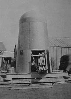
Installation of the 50 foot observation tower, located behind the HECP
casemate, was started on March 13, 1943, and completed in September
1943. This tower had an electrically heated, wooden topside structure,
approximately 16 feet square, with a 2 and 1/2 foot wide catwalk that
extended around the structure. The tower was constructed by the Ordnance
Department for use at the Sandy Hook Proving Ground. When the Proving
Ground was discontinued in 1919, the
tower was transferred to the Coast Artillery and pedestals and fire
control optical instruments were installed by the U.S.E.D. in 1926.
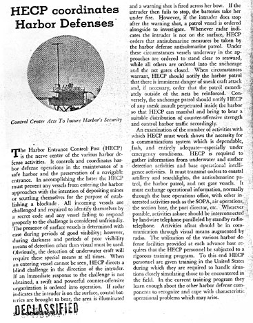
The function of the HECP was: "to collect and disseminate
information of activities in the defensive sea area, to control
unescorted commercial shipping in the defensive coastal area, and to take prompt and decisive action to operate the elements of
the harbor defense, in order to deny enemy action within the defensive coastal area".
The HECP was also tasked with maintaining a navigable entrance to the
New York harbor by preventing enemy ships from laying mines or scuttling
themselves to block the harbor entrance.
The Advance HECP #2 at Fort Tilden was used to identify ships
approaching the Ambrose Channel from the waters off Long Island, and to
keep fishing vessels and pleasure craft out of
the restricted areas off the shores of Fort Tilden. The Advance HECP #1
at Fort Hancock performed similar duties on the West side of the
Ambrose Channel. This structure was built into
the remains of Battery McCook (8, 12" Mortars, 1898-1923).
When an unidentified vessel entered the defensive area, the HECP would
direct a blind challenge, if an immediate response to the proper code
was not received the HECP would organize a powerful offensive attack.
If the harbor surveillance radar indicated that a surface ship was
approaching, the area was illuminated with spotlights, and a warning
shot was fired from the coastal gun batteries. If the intruder failed
to stop, the batteries would open fire upon the ship. If the intruder
did stop, a patrol vessel would be dispatched
to investigate.
If the unidentified vessel was detected by the undersea magnetic
detection equipment and no surface ship was detected by radar, a
submarine was presumed to be in the harbor. Any friendly vessels
approaching the harbor were advised to stay clear of the
harbor, the harbor patrol was notified and the submarine net gates were
closed.
All communications were conducted by landline telephones, backed up by
two-way radio equipment. Light and flag signals could also be used for
communications.
A staff of four officers and 20 enlisted men were authorized for the
HECP at Fort Tilden.
Fort Tilden's HECP was located in a casemate equipped with a ventilation
system designed to protect the occupants from poison gas attacks.
Plumbing, electrical, communications, and dehumidification systems were
installed to serve the
staff and equipment. The casemate contained two large rooms designated
Room A and Room B, an enlisted men's latrine, an officers latrine, a
radio room, and a central corridor. The casemate had it's own boiler
room, coal bin, cable hut, and is accessed through an air lock. The
floors were covered with
linoleum tiles and the ceiling was covered with 2" acoustical material.
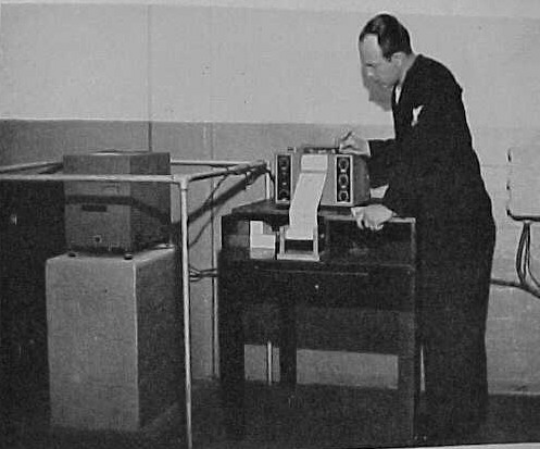
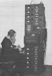
Fluxmeter and recorder installed in HECP casemate
(US Navy photo)
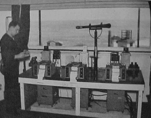
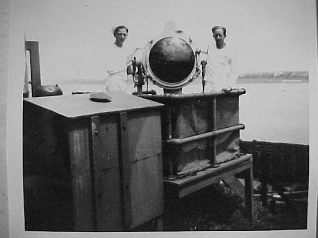
Three fluxmeters and recorders installed in observation tower.
(US Navy photo)
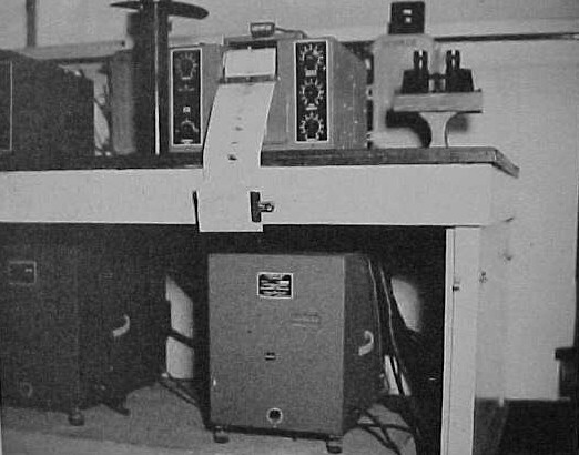
Details of fluxmeter and recorder installed in observation tower.
(US Navy photo)
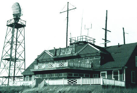
HECP Signal Tower, Fort Wadsworth, NY, 1942.
(Bernard Norris photo)
Signal light at HECP Signal Tower, Fort Wadsworth, NY, 1942.
(Bernard Norris photo)
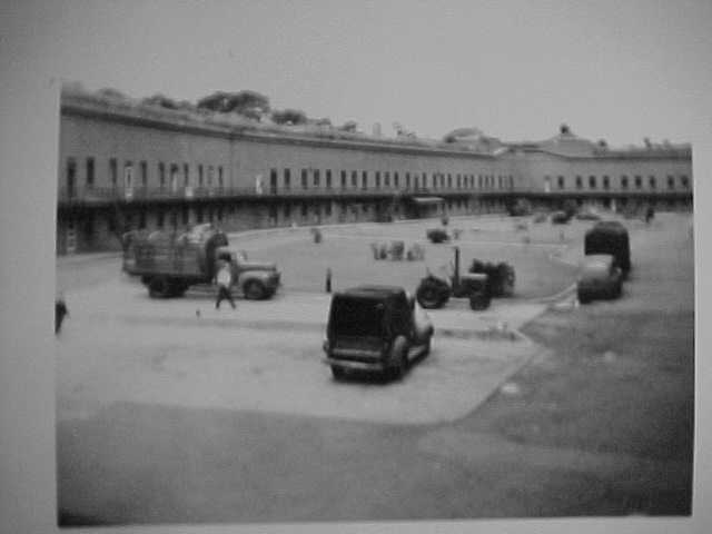
Courtyard within Fort Tompkins as viewed from HECP, Fort Wadsworth, NY, 1942.
(Bernard Norris photo)
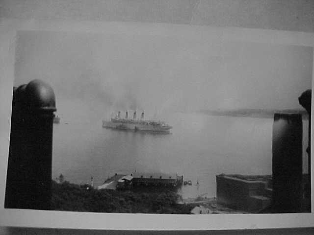
USS Aquatania entering NY Harbor, viewed from HECP, Fort Wadsworth, NY, 1942.
(Bernard Norris photo)
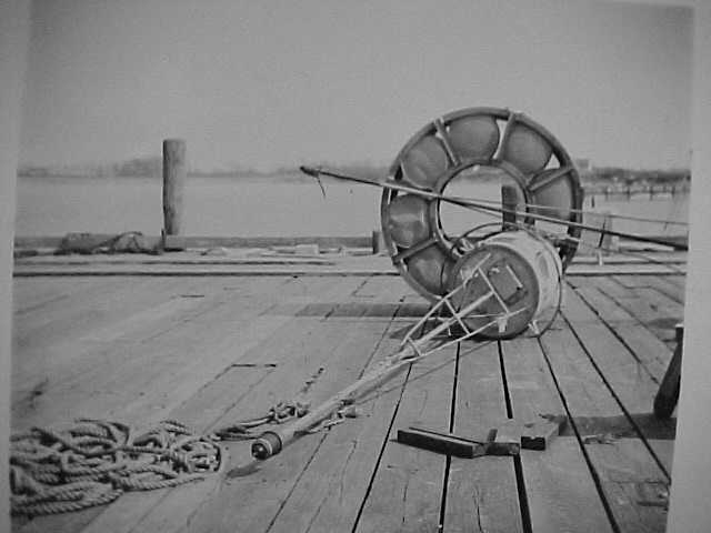
QCP HERALD Hydrophone equipment.
(US Navy photo)
QBC-1 HERALD Hydrophone equipment. This unit was mounted on the harbor floor and acted as a directional hydrophone.
(US Navy photo)
This RBF-1 was a rack of VHF radio receivers that was used to listen to signals from up to 10 sonobuoys.
(US Navy photo)
Type JM sonobuoys were floating hydrophones and radio transmitters
that sent audio signals back to the HECP for analysis by Navy Soundmen.
These were anchored into position and required periodic battery
replacement.
(US Navy photo)
ADVANCE HECP #2, FORT TILDEN,
ROCKAWAY POINT, LONG ISLAND, NEW YORK:
This is a portion of a history of the New York Harbor HECP
(circa 1945). The complete report is available at Fort Tilden.
Advance HECP went into operation on 6 August 1943 at Fort
Tilden, Rockaway Point, Long Island, New York, an Army fort
constructed at the time of World War I and greatly expanded
during this war. Preliminary surveys for the installation
of this HECP unit considered a structure on the top of the
Half Moon Hotel, Coney Island, or the Army Radar Tower, Fort
Tilden, which had an elevation of 173 feet. Both these
sites, however were rejected in favor of its final location,
as more central for joint Army-Navy action.
a. Mission
The principle tactical mission of Advance HECP #2 was to
establish the identity and to determine the character of the
ships passing along the Long Island shore before approaching
Ambrose or Rockaway Channels. Its main secondary mission
was to prevent fishing vessels and pleasure craft from
entering the restricted area before the Fort Tilden gun
emplacements.
b. Operations:
1. Ship plot was maintained in the contiguous waters.
2. Unit 3-C (Navy operated loop station) was operating in
conjunction with this HECP, unlike Naval Unit 3-A at Sandy
Hook. (For further information see Section on MAGNETIC
INDICATOR LOOPS.)
3. A radar sweep was theoretically possible by means of an
auxiliary SN radar unit, but actually this unit was
unsatisfactory in operations, as it rarely could reach out
to the extent of the loops, (as explained in the section on
RADAR).
c. Operations Office Space:
Joint Army-Navy Operations Room, occupied 6 August 1943 and
wholly completed 15 December 1943, 400 square feet of floor
space, 4,000 cubic feet of space, located in bomb proof
center built by Army for HECP and Command Post, heated by
forced warm air heat; Tower and Generator shack (Army owned
and erected for HECP and Command Post.) Tower located back
of bomb proof, 50 feet in height, electric units heated
topside structure, 256 square feet of floor space, 2400
cubic feet, 2 ½ catwalk on outside, 4 sides 43 feet high, 60
feet above. Used head in bomb Proof shelter.
d. Personnel:
Total complement authorized was four officers and 20
enlisted men. Enlisted men were housed in a double deck Army
barracks and messed with various Army batteries until August
1944, at which time they were transferred to the Fort Tilden
Coast Guard Station mess to give them the benefit of the
best possible mess. Officers were housed in Army Bachelor
Officers' Quarters and messed with Fort Tilden Army Officers
mess. Recreational facilities of the Army at Fort Tilden
were made available to all Naval Personnel on duty there.
The station beach, which included three clubhouses, one for
officers, one for a searchlight moved down from Fort Tilden,
to serve as a Navy Signal and Mine Watching Station, it the
ship traffic required an extension of the existing signal
system, but this contingency did not come to pass, and the
tower was never regularly operated. The authorized enlisted
complement was as follows: 1 CBMA, 6 SoMH2c,, 4 SoMH3c, and
1 SC-Striker-S2c; total 13.
d. Naval Unit 3-C, Fort Tilden, Rockaway Point, New York:
This Unit was set up under orders of 11 December 1941,
providing for magnetic loop installations for New York
Harbor. This station was located at Atlantic Beach Coast
Guard Station on Far Rockaway Inlet, Atlantic Beach, Long
Island. At this time the station was known as Naval Unit -#2.
Two magnetic loops were laid, known as Loops 3 and 4.
The shore equipment consisted of three fluxmeters, two in
use and one spare, and telephone communication to HECP at
Fort Wadsworth. A fluxmeter and visual watch was maintained
by one chief and eight seamen starting 14 March 1942.
All crossings on loops were reported by telephone to HECP
and the visual watch attempted to identify the ships making
the signatures, Because of technical difficulties
experienced, due to nearby railroad (discussed below,) it
was decided to move the station from Atlantic Beach to Fort
Tilden. Concomitantly it was decided to improve the
procedure of reporting the movement of vessels in New York
Harbor by the establishment of two advance HECPS. Shortly
after 17 September 1943, Naval Unit #2 became Naval Unit 3-B
and was set up as an organization separate from the Advance
HECP #2, but working closely with it. In place of the two
unsatisfactory loops (Numbers 3 and 4) originally laid from
Atlantic Beach, three loops were laid with Fort Tilden as
the shore terminus. When completes the loop system had as
its approximated eastern edge, a line from the HECP Tower to
the Ambrose Lightship. The tail cables were brought into a
bombproof shelter where four fluxmeters were located.
Subsequently it was decided to relay three new loops in
place of the original two. The new loops gave excellent
results. Loop 4 was able to operate at the highest
sensibility most of the time and loops 5 and 6 gave fine
results, but being closer to shore experienced greater
disturbances than loop.
4. The limitation of these loops were only those of the
system and the equipment used. A more sensitive loop could
have been used. Clear signatures were obtained on all but
the smallest trawlers used in fishing and 38-foot, private
cabin cruisers. Multiple turn loop systems with
discriminators could probably pick up these craft. The
water conditions on the eastern side of the harbor are very
favorable to the use of loop equipment. The loops laid
across the Western Approaches to the New York Harbor (Shore
Terminus; Spermacetti) gave satisfactory performance. On 12
April 1945 Loop 3 was put out of operation when the outer
leg of the loop was cut by a ship dragging anchor. This was
never repaired, and shortly after cessation of hostilities
in the European theater, on 28 May 1945, all loops were
secured. In the final analysis it is the opinion of the
last Officer in Charge at Fort Tilden that magnetic
indicator loops were the most successful of all detection
devices used in New York Harbor as their findings were
scientifically exact, and independent of human analysis.
e. Difficulties Experienced in Loop Operation in New York
Harbor:
(1) When the loops were first laid from Atlantic Beach and
Spermacetti Cove, none of the men were familiar with the
equipment with which they were working. In addition,
visibility was such that it was often almost impossible to
identify vessels at any great distance during the day and
totally impossible at night.
(2) The original loops (out of Atlantic Beach) were far too
long and were not laid tightly enough. The cable could
swing with the sea action, causing wide swings of the
recorder pens.
(3) It was also found that the Long Island Railroad, which
ran an electric line that paralleled a mile of the tail
cables, caused even more perturbations. The smallest ship
that could be picked up by the installation was a harbor
tanker. Even these signatures were very difficult to
distinguish from the disturbances recorded. They could only
be identified by the shape of the signature as the magnitude
was not greater than that of the perturbations. The watch
standers became skilled at distinguishing signatures but at
no time could confidence be placed in the results obtained
by the Atlantic Beach Station.
(4) The greatest and most crushing difficulty was the
destruction of loops by merchantmen dragging anchor in
restricted cable areas. (These ships were anchoring in
restricted cable areas up to the last week of HECP's
operation, despite all warnings and protests.
(5) Much intelligence gleaned from loop signatures was
obscured, reduced in value, or rendered useless, multiple
loop crossings. These uncontrolled crossings continued up
to the time the loops were secured. In order for loop
signatures to of maximum intelligence value, it is necessary
for traffic to be so regulated that not more than one ship
at a time crosses a loop.
(6) From time to time there have been unverified loop
signatures, which after deliberation and experience, were
believed to have originated spuriously due to shifting of
the earth's magnetic field.
f. Experimental Loop for Distinguishing Inbound from
Outbound Traffic:
ComTHREE letter dated 15 December 1943, subject Underwater
Magnetic Indicator Loops, Determining Direction of Crossing,
make reference to permission granted by Vice Chief of Naval
Operations to "install a trial loop (unequal area) in outer
New York Harbor," and further stated that VCNO had
"requested the Commandant, Navy Yard, New York to make this
installation inside of Loops #2 and #3." It went on to say
this trial loop was laid at a designated spot and terminated
at Naval Unit 3-A Spermacetti Cove, New Jersey. (See
Appendix FF.)
(1) ComTHREE letter dated 4 February 1944 addressed to
BuShips, tells of the success of the trial loop: "Definite
indication of direction was obtained with this trial loop as
evidenced by enclosure (1), a photostatic copy of a sample
signature on fluxmeter tape, giving authentic evidence of
desired results, which shows typical signature of an inbound
and an outbound vessel." (See Appendix GG.) The trial loop
was laid with the distance between the center leg and outer
legs. Therefore, an outbound vessel makes a signature
wherein the time required to cross between the inner and
center legs is approximately twice that required for
crossing the center to outer legs. An inbound vessel gives
a reverse type signature.
(2) "On 3 January 1944, ships anchoring in a northeasterly
storm, dragged anchor and cut all three legs of this loop.
As other ships also damaged tactical loops #2 and #3,
priority was given to the repair of those loops prior to
repair of the test loop." (Trial loop was never made
workable again.) Loops #2 and #3 were repaired 28 February
1944.
(3) Although the exact dates on the Unit 3-C log is not now
available, it was learned through telephone conversation
with an officer in the Radio Material Office that loop 2 had
all three legs out by a ship dragging anchor in the fall of
1943 at about the same time loops 3 and 4 were being picked
up at Atlantic Beach.
(4) Technical consideration made it advisable to create two
loops in place of the one damaged loop 2, this being done by
running out another tail cable.
(5) As a result, the loops monitored at Spermacetti were
redesignated as follows: loop 1 remained same; loop 2 make
into two loops became 2A and 2B, When the loops at Atlantic
Beach were picked up, and three new ones subsequently laid,
these were designated 4, 5, and 6. In line with this changes
loops 2A and 2B were redesignated 2 and 3 respectively.
HYDROPHONES
New York Harbor hydrophones were Army installed and Army
operated. (For approximate positions see Appendix B.)
Located on the ocean bottom, the acted like large telephone
earphones and were wired into a "squawk box" located in the
mine case mates at Fort Wadsworth, Fort Hancock, and Fort
Tilden. Hydrophone signatures were essentially as difficult
to analyze as sono-bouy findings, due to the heavy traffic
of New York harbor in constant movement. A destroyer might
be calibrating off Cholera Banks and drop a practice
exercise "ash can." Any hydrophone was sensitive enough to
record it, way back in the Narrows. But although the
hydrophone signature made it known that an underwater
explosion had occurred, a basic operational inadequacy lay
in the fact that there was no way of knowing from which
direction or at what distance that explosion occurred. In
the course of the war, the positions of the hydrophones were
moved many times. In actual operations they proved of
doubtful value.
Furthermore, no real attempt was known to have been made by
the Army to tie them in with HECP activity.
ANTI-SUBMARINE NETS, ANTI-MOTOR BOAT NETS, BOOMS, GATES, AND
NET VESSELS:
The nets and booms of New York Harbor were laid by the U.S.
Navy Net Depot, Bayonne, N.J., and came under the command of
Commander Ambrose Section although the two net vessels came
under the tactical command of HECP Fort Wadsworth. These
vessels consisted of the YNG-3, whose chief function lay in
assisting when the net gates were closed and opened, and the
YNG-39, the "flag" ship, whose signal bridge was manned 24
hours a day, always by one man but in heavy traffic by two
men. (For relative position see Appendix B. For detailed
construction see Appendix EEE.) Neither of these vessels
had any propulsion but were moved by tugs. Each had a power
generator for electricity and steam. The YNG-3 was put into
position on 27 November 1941; then at a later date the YNG-39 was added, taking the old position of the YNG-3 on the
west side of the Channel.
a. Functions of Net Vessels:
(1) The first function of these ships was to control the
net gates, of which there were two. In the early stages of
the war the main gate was usually closed from about 0000 to
0300, but later when convoys were routed to depart late at
night it became the practice to leave the gate open at all
times, except in emergency on order of the HECP. The
auxiliary gate when installed was open only when large
convoys were in movement, and was operated by a third YNG
put into position in the spring of 1944.
(2) The second function of these vessels was to assist in
the identification of harbor traffic. Each ship, whether
inbound or outbound, was challenged before she reached the
gate. Flags were used by day, blinkers by night. Movements
were regularly checked with both the Ambrose Guard Vessel
and HECP, Fort Wadsworth.
(3) A third and highly strategic function was to provide a
watch by means of underwater sound gear. The YNG-39 was
equipped with both listening and ASDIC devices. During poor
visibility she maintained a constant search to the seaward.
(4) A fourth and purely courtesy function of the net
vessels was to assist the Degaussing Section at Swinburne
Island by directing vessels to the proper area for
degaussing. (See Section on SHIP INFORMATION PROCEDURE.)
b. Communications:
The YNG-39 possessed one Magneto type telephone circuit,
Navy laid, to Hoffman Island, which provided direct
communication with HECP, Fort Wadsworth and with Swinburne
Island. She had no radar and only a small radio transmitter
and receiving set, suitable for conversation with the HECP
Roving Patrol YP's and with HECP Fort Wadsworth. The YNG-3
had neither a telephone or a radio and relied purely on
visual signaling with the YNG-39 for her communications.
c. Armament:
The YNG-39 was armed with one 50-caliber machine gun, two
30-caliber machine guns and one 1-pounder or "heave to" gun.
The YNG-3 was unarmed except for Thompson machine guns. To
maintain the ship in a state of readiness the YNG-39 in the
early stages of the war called "general quarters" once a
day.
d. Personnel:
Personnel consisted of two officers and eighteen to twenty-two enlisted men.
All enlisted men were assigned from the Naval Frontier Base,
Tompkinsville, Staten Island. The
watch bill was so arranged that each man had six days aboard
the net vessels and two days ashore. Nobody took regular
watches except the signalmen on the bridge who stood four
hours on and twelve off. When the net vessels were first
put into operation all personnel was white; in February 1943
the first Negro personnel were put aboard, and finally all
enlisted personnel were Negro. Sometime after VE Day (exact
date unknown) the Coast Guard too over the operations of the
vessels at which time all Naval personnel were removed.
e. Harbor Transportation:
Transportation to and from the shore was provided by a YP
from the Naval Frontier Base, which was also responsible for
bringing out the food and other ship's supplies.
f. Disestablishment:
The YNG-3 was left temporarily at the Narrows while the
YNG-39 was given a complete overhaul, and her winches removed.
From 28 July 1945 the YNG-39 then resumed her former
position in the Narrows as a traffic control vessel.
(End of report)
Other HECP Locations
Many HECPs were established at critical harbors on the Atlantic and Pacific coasts of the United States and it's territories:
District # ---- Station ----- Location ----------- Latitude -
Longitude
1 -- Portland, ME -- Fort Williams -- (N43-37-15, W70-13-00)
1 -- Portsmouth, NH -- Ex-Coast Guard Station (Fort Stark, Battery
Kirk) -- (N43-02-30, W
70-42-00)
1 -- Boston, MA -- Fort Dawes -- (N42-21-30, W57-30)
1 -- Newport, RI -- Beavertail -- (N41-27-00, W71-24-00)
3 -- Fishers Island -- Fort HG Wright -- (N41-15-22.8, W72-01-23.9)
3 -- Staten Island, NY -- Fort Wadsworth -- (N40-36-15, W74-03-22)
4 -- Delaware -- Cape Henlopen (Fort Miles) -- (N38-47-39,
W75-05-32)
5 -- Norfolk, VA -- Just outside Fort Story -- (N36-55-48,
W76-00-42)
6 -- Charleston, SC -- Fort Moultrie -- (N32-45-33, W79-51-31)
7 -- Key West, FL -- To be established
8 -- Santa Rosa Island, FL -- (Fort Pickens, Battery Worth) --
(N30-19-30, W87-17-
30)
8 -- Galveston, TX -- Fort Point (Fort San Jacinto) --
(N29-20-00, W94-44-37)
10 -- San Juan, PR -- (Fort Brooke, El Morro) -- (N18-28,
W66-07) 10 -- Vieques Sound (Roosevelt Roads), PR -- Punta Algodones
11 -- San Diego, CA -- (N32-40-19, W117-14-24)
11 -- San Pedro, CA -- Fort MacArthur (Battery Leary and Merriam)
(N33-42-42, W118-17-
32)
12 -- San Francisco, CA -- Fort Winfield Scott (Dynamite Battery)
-- (N37-48-08.3, W122-28-
32.7)
13 -- Columbia River -- Fort Stevens (Battery Mishler) -- (To be
established)
13 -- Puget Sound Area, WA -- Fort Worden -- (N48-08-30, W122-46-00)
14 -- Pearl Harbor, HI -- NavyYard Pearl Harbor -- (N21-21-11.9,
W157-57-26.2)
15 -- Cristobal, Panama Canal Zone (Atlantic Side) -- Fort Sherman --
(N9-22-00, W79-57-00)
15 -- Balboa, Panama Canal Zone (Pacific Side) -- Fort Amador --
(N8-55-00, W7931-00)
16 -- Manila Bay, Corregidor -- Fort Mills -- (N14-22-59,
E120-34-23)
Note 1: Lat-Long coordinates are provided for plotting purposes, to
locate sites with GPS navigation units, and to utilize the Microsoft
Terraserver Satellite photograph
database.
Note 2: Comments in italics added by author to reflect actual
locations.
If you have any information on the history or current condition of any
of these former HECP facilities, please contact us. Any photographs of
the exterior, interior, or equipment would be of
great interest to us.
Photo: HECP - Fort Burnside, RI (From: Varoujan Karentz EPICV@aol.com )
Sources and further reading:
United States Army in World War II, The Western Hemisphere,
Guarding the United States and it's Outposts,
Office of the Chief of Military History, Department of the Army.
Special History Study, Fort Moultrie HECP-HDCP, Edwin C. Bearss, National
Park Service, May 1974.
The Fort Wadsworth HECP, US Navy, 1945(?)
Naval Harbor Defense, U.S. Navy, OPNAV 30-3A
Photo: Page from Naval Harbor Defense, U.S. Navy, OPNAV 30-3A